 1997-1998: the dawn of Girlpower, Harry’s first year at Hogwarts School of Witchcraft and Wizardry, and the epic story between love, an iceberg and a ship. Oh, and yeah…..El Niño.
Documented as the strongest El Niño to ever occur within the past 50 years, the 1997-1998 ENSO (El Niño Southern Oscillation) event broke records for heightened sea surface temperatures, rainfall, and drought conditions globally. With ENSO occurring regularly every 4-5 years there’s no lack of expectation of what’s to naturally happen. It is, although, varied by intensity. 2015 marks the beginning of another El Niño event, and this year is anticipated to steal the cake. Recent trends give evidence to the possibility that this year could reach and even surpass 1997-1998 records with how high sea surface temperatures of the water have been.
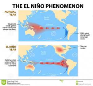
 This natural, cyclical phenomenon transpires when easterly trade winds along the equator weaken, shifting atmospheric and oceanic circulation patterns. Normally, cold-nutrient rich water is upwelled along the eastern Pacific coast near Peru due to strong trades pushing west. This keeps the areas around the eastern portion of the equator relatively cool and dry during portions of the year, and highly productive given the movement of bottom-dwelling nutrients to the surface. Along the western side, the warm water being pushed by the strong winds eventually warms the overlying air over Indonesia and other portions of Southeast Asia. The air then gets lifted into the atmosphere and produces variable stormy activity that keeps this area relatively warm and wet during the year.
What commences an El Niño event is the weakening of the easterly trade winds. The normal cold-water upwelling occurring along the eastern Pacific coast that we typically see comes to a halt, allowing warm water to pool up. Atmospheric weather patterns shift more eastward, producing more wet, stormy conditions along the eastern coastlines. As a result, we find more warm, wet, and non-productive conditions along the east side and more warm and dry conditions over towards the west.
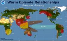
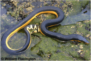 The intensity of ENSO events varies each year based upon the overlay of building oceanic and atmospheric conditions throughout the designated year. Only time will tell on how strong this year’s El Niño will be. What is anticipated to happen around California and Catalina Island, although, is higher than normal precipitation in the form of rain and even snow up in higher elevated areas, increased susceptibility of weather-induced natur al disaster events, including landslides and mudslides, and major ecological shifts within our local terrestrial and marine environments. We’ve already seen a number of non-native marine critters visit, including the recently sighted venomous Yellow-Bellied Sea Snake…..watch out!
The important thing to understand is that El Niño is a natural reoccurring phenomenon. It’s not alien that we are going to experience an intense shift in climate and weather patterns this winter seasons or quite possibly even see Godzilla emerging from the sea. What is curious, although, is the question of how intense that shift will be and how our ever changing world has contributed to that intensity.
Written by John Cornett
Blog Photo Credits
-“El Nino Pacific”
https://www.taskeasy.com/blog/2015/09/21/what-el-nino-could-mean-for-2015-16/
-“Global Climate Conditions”
http://www2.ucar.edu/news/backgrounders/el-nino-la-nina-enso
-“Yellow Bellied Sea Snake”
http://www.californiaherps.com/snakes/pages/p.platurus.html
Video Photo Credits
-“Landslide”
http://gallery.usgs.gov/search/Photos/landslide/thumbettes/08_18_2015_vbr1Uhg7SO_08_18_2015_0/1
-“Yellow Bellied Sea Snake”
http://www.californiaherps.com/snakes/pages/p.platurus.html
-“Mudslide”
http://www.smartgivers.org/smart_giving_in_response_to_california_mud_slide_2
Snow Caps
http://articles.latimes.com/2013/jun/14/science/la-sci-sn-southern-california-snow-20130614